
We offer a comprehensive and continuous dataset to give you unique insights across multiple industries.
Insight
Our integrated data insights can be viewed and continually assessed with our software platform, Russell ALPS.
Analysis
Our expert consultants can take a customised and commercialised approach to problem-solving to suit your interests or situation.
Action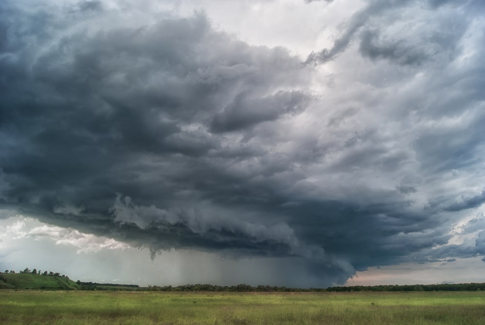
Declared on 30th November 2022 by the World Meteorological Organization (WMO): The first “triple-dip” La Niña (three consecutive years) of the 21st century will continue to affect temperature and precipitation patterns and exacerbate drought and flooding in different parts of the world. In fact, it is only the third time since 1950 this has occurred.
La Niña refers to the large-scale cooling of ocean surface temperatures in the central and eastern equatorial Pacific Ocean, coupled with changes in the tropical atmospheric circulation, namely winds, pressure and rainfall. It usually has the opposite impacts to weather and climate events such as El Niño, which is the warm phase of the so-called El Niño Southern Oscillation (ENSO) which often makes headlines along the eastern side of the Pacific.
Put simply (in the context of New Zealand) the equatorial trade winds which blow East to West across the Pacific usually transport warm waters westwards in its direction, these ebb and flow seasonally and intra-seasonally resulting in warmer and colder sea surface temperatures along their shorelines. During La Nina events the strength of this ‘pushing’ increases, forcing a greater transport for, or mechanisms, to promote warmth across New Zealand.
This (triple-dip) event has resulted in more and more warmth being pushed further west and south than has typically been seen before, and so the sea temperatures increase over time. This time it has been 3-years. The effects of this increase is that the New Zealand Met issued a ‘Marine Heatwave’ warning (some areas with temperatures 2-3 degrees above average) for the northern waters of NZ resulting in an increasingly hospitable environment for rain/storm – even cyclone events.
Meanwhile, Tropical cyclone Gabrielle, currently out in the Coral Sea, is heading straight towards the North Island of New Zealand. Gabrielle is forecast to bring further extreme rainfall totals (250-300mm) across Auckland and surrounding areas, exacerbating the saturated ground conditions from a legacy of the record-breaking rain event 27/28th January this year – risking further flooding, possible landslides and infrastructure damage, costing up to an estimated 0.5$bnNZ suggested by infometrics, a New Zealand economics consultancy.
Note this event itself dropped 250mm in places - nearly a quarter of Auckland’s average annual rain (~1100mm), and so close to half the annual rain could fall in these two events in the first 2 months, which is staggering.
The triple threat from a storm of this type is the storm surge – as the storm approaches land it pushes water ahead of it to pile up, prompting the New Zealand Met service to issue a ‘Heavy Swell’ warning coinciding with rain & wind watches.
The exact path of the storm remains uncertain. However, one thing which is becoming more certain is the longevity of this storm and its impacts as it stalls and slides slowly South, resulting in the Mayor of Auckland his extending the ‘State of Emergency’ conditions until at least into next week. The rainfall event in January triggered over 20,000 damage claims, predominantly from the Auckland area. The impacts of this storm could stretch wider across the country, with the addition of wind and storm damage resulting in even more claims.
We may see yet more rain in the aftermath of this event. A crumb of comfort perhaps is that La Niña conditions do look to be gradually weakening (at least in the ocean), so conditions will gradually become less hospitable for storms across NZ. Sadly, the timelines of this change will be too long to make a difference to this current summer season, so the authorities should remain an elevated preparedness across this region now, and for at least the next few weeks.
Whilst these storms might seem sudden and without warning, it is possible to connect these events back to larger scale weather drivers such as the ENSO and the pre-conditioning factors of previous rain events in this area which happened weeks/month prior. Therefore, as we endeavour to improve predictions in the future to maximise preparedness and time for action – it pays to look back first.
Warmer weather may increase the likelihood of tropical diseases, such as dengue fever and malaria, reaching New Zealand. New Zealand is too cold for mosquitoes and ticks which spread tropical diseases, however, as the climate warms they may be able to establish populations here.
The hazards posed by frequent and extreme weather events such as flooding, storm surges, forest fires and ex-tropical cyclones could affect people’s health, which has implications for policy-makers and industries such as the health sector and the connected life insurance sector.
As a blog by National Institute of Water and Atmospheric Research explains:
“Two thirds of New Zealanders live within 5 km of the coast, so sea-level rise will directly affect many. Sea-level rise is caused by melting of the polar ice caps, as well as expansion of ocean water as it warms. In New Zealand, the sea may rise by up to a metre by the end of the century. This will mean more coastal erosion and flooding, which will damage homes and infrastructure like pipes and roads.”
New Zealand will also have to think about our water supplies, but not only during dry periods.
For example, a good example of connected risk occurred in March 2017, when a huge storm called 'The Tasman Tempest' descended on Auckland. According to the NIWA: “Unprecedented amounts of rain fell on the Hunua Ranges causing massive slips into water reservoirs, contaminating drinking water with silt. Water restrictions were put in place and water managers realised that they would have to plan for similar events in the future.”
Auckland Airport is having to prepare for Cyclone Gabrielle only weeks after torrential rain left terminals flooded and passengers wading through water.
The airport has announced that every part of their system is currently hard at work to make sure its staff and operations are ready to safely manage the predicted weather.
According to Aerotime Hub: “On the airfield, the integrity of the runway and the safe movement of aircraft come first, and our team will be monitoring the airfield continuously throughout the severe weather. If they see any risk of foreign object debris, we will immediately close the runway – something that is standard practice for us regardless of weather conditions,” said Auckland Airport Chief Executive Carrie Hurihanganui.
It’s too soon to say whether the latest weather event will have a similar connected risk impact on businesses in New Zealand, however, Russell will be monitoring the impacts across sectors, which include aviation, through its ALPS Aviation solution.

Related Articles
Reinsurance
Reinsurance
Reinsurance
